River and ocean water slide past each other

When the tidal current starts to ebb through Raccoon Strait, a very discrete band of brownish water is often seen pushing South-West toward the Golden Gate. This is just an earlier phase of the current seen in the aerial photograph (previous section). There is a sharp boundary between river and ocean water; the color changes in just a foot or two, and there is often a band of foam between the two zones.

The river water behaves as if it were a semi-solid material moving through semi-solid ocean water. Within each of these water types the velocity is fairly constant, and thus the change in velocity between the two must occur at the boundary between them. The velocity profile across the surface of the water is revealed when a boat crosses the river water plume and leaves a wake. As seen in the Figure to the right, the wake (the white line) is broken into several segments as the river water moves downward. Thus river and ocean water behave similarly to the tectonic plates on the surface of the earth.

Aerial view of river water pushing through (or sliding over) ocean water.

Observation of river-ocean water boundry

The river water forms a distinct stream with a light green-brown color in contrast to the darker blue ocean water. Sometimes a line of foam or a sharp change in the texture of the wind waves also marks the transition between the two types of water.

However, none of these visual cues reveals the velocity profile of the current. If a boat, e.g. the Sausalito to San Francisco ferry, passes through the plume, its wake gives a direct verification that the color change indicates one stream of water moving through another.

As the boat moves through the band of water, the wake becomes fractured at the boundaries of the current plume. Each minute the segments of the wake on each side of the boundary separate by another hundred feet or more. The segments of the wakes remain quite straight, although of course they are all moving outward from the path of the boat.

The vertical white bars have been added to mark the break in the left wake as it crosses the river-ocean water slip line.

More examples of the river-ocean water boundry

The ability to see surface movement of water in the bay is very dependent on the wind speed and direction and the angle of the sun in relation to the observer. There are no simple rules (that I am aware of), but in general the wind should be of low to modest velocity and the sun should be at a low angle to the water so you can see its reflection in a small portion of the waves.
In the photograph on the left we are looking up Raccoon Strait (to the NE) from a site about 200 ft above the center of Sausalito. The Belvedere penensula is in the upper left and Angle Island is seen in the upper right. A flood current is pushing the darker ocean water into Richardson Bay, as seen in the lower right part of the frame. You can see turbulence and foam at the boundary between the light, older river water and the invading ocean water.
Now the ocean water in pushing up into Raccoon Strait. There is still a sharp boundary between the ocean water and the older river water in Richardson Bay.

The actual details of the motion of the water are very complicated, and there is a great deal of variation from day to day. To form any quantitative model of the motion would require a regular series of images from a more elevated position.

In the photograph to the right we are at the same location, but looking more to the South. There is a lot of fog, but the Southern tip of Angel Island (Blunt Point) can be seen in the upper middle of the frame. The "red 2" marker, which is atop a "telephone pole" is in the middle left. The wind, which is blowing the fog in through the Golden Gate, has generated a dense field of small water waves which are revealed by the reflected light of the sun. The sharp boundary in the intensity of reflected light marks the line between ocean and river water.

A theory for stability of the river-ocean water plume

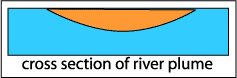
A density gradient stabilizes the boundry: The river water is lighter than the ocean water because it contains less salt and is warmer. Thus it floats on top of the ocean water, as shown in the Figure to the right (a cross section along the direction of flow). Within the bulk of both river and ocean water the flow is turbulent and there is thus mixing. This mixing (shown by the velocity arrows) keeps both the composition and average velocity essentially uniform (in the Figure the average velocity of the top layer is to the left while the average velocity of the lower water is zero).

However, at the boundary there is a gradient of density, and this gradient keeps the boundary stable. If a small volume of heavy water starts to move upward, it enters lighter water and sinks back down. If a small volume of light water starts to move down, it enters heavy water and is pushed back up. Thus the flow in the boundary gradient is laminar, and mixing is slow.

Why are the edges of the plume stable?

I propose that the boundry of the plume is never vertical (in which case there would be no stability), rather, the cross section (perpendicular to the fow) is a shallow curve, so even at the edges there is a strong vertical componant and thus stability.

Return